Mt Palerang: Ascent 2021 (Challenging 3km, 180min, 300m ascent)
I had watched the wildfire hit Mount Palerang 18 months earlier, but had only seen the ragged slopes from a distance since, as access to the area has been closed until recently. Yesterday, I climbed the mountain with Indy, my gym instructor. The purpose in ascending the mountain was to catalogue surviving species, observe the bushland recovery at first hand and record a safe track to the peak.


General observations
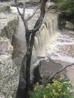
Access from Braidwood along the Mulloon Firetrail is straightforward and relatively safe (we struck recent fallen trees across the firetrail in a couple of places - and heard trees falling on a couple of occasions during our hike). Access from Forbes Creek is possible with a 4WD, but you may be blocked by water or erosion at Mulloon Creek, and there are dangerous unmarked gutters/holes in the road at several places. The old stone work at the Chinese Walls is still holding the road, but...
The trek up the mountain itself is dangerous. There has never been an 'official' trail to the peak - but there is a fairly well worn track that appears from time to time to avoid rocky outcrops. These paths might follow the ancient Yuin Trace spur line giving line of sight to Lake George to the north-west and the plains around Mount Gillamatong.
The first part of the path, from the intersection at the four ways (the road from Braidwood and Palerang Fire Trail) to the first shoulder is heavily eroded and very slippery with lots of loose rocks - climbing up is a lot easier than climbing down. From the shoulder, the path becomes much easier - follow the faint path until you spy the first of a series of pink trail markers. The markers are infrequent but very useful visual guides to the worn track which will disappear from time to time. I have made my GPS map trace visible on Gaia and include a link at the end of this post.
Warnings
There are signs of pigs and wild dogs on the mountain. Trees are still falling - branches will fall in strong winds or simply explode in still conditions. Do not come here alone. Bring water. The trek may take 2-3 hours, and much longer if you loose the trail.
Be wary of using Google maps to help you with the ascent. Ignore the Google path suggesting a possible short scramble up the east face of the mountain without taking ropes and leaving your will with the authorities. Google and other on-line apps may locate the peak a little to the south of the actual trig.
Braidwood to Mulloon Fire Trail / Palerang Fire Trail intersection


There is a rough parking area at the intersection.

First climb
Take two strong sticks.
The track to the top of the shoulder starts as a fairly indistinct affair about 50m along the Palerang Firetrail on the right hand side. There are at least two eroded paths up the mountain to the first shoulder (i have marked both on the Gaia trace).

This isn't mountain climbing - more like climbing up a dry waterfall. Going up slowly is ok - coming down is a nightmare.


Shoulder
From the shoulder tend left around the rock face until you find the first pink trail marker. This part is fairly flat.
The shoulder - summit walk took us past healthy colonies of everlastings, peas, hibbertias, and fan flowers.


Summit


Nearby


Mapping


Comments
While a lawyer by trade, i did a lot of fire fighting in the mountains, and it is through that unlikely connection that i have grown to fear and love the local mountains, despite their population of 8 different types of funnel web spiders and the largest dingoes in the country (taking care not to mention some of the other larger animals that one occasionally gets glimpses of).
I climbed Palerang the week before the terrible fires, and now have cause to regret the poor photo shots from that climb - despite a horrible drought, i found a profusion of wildflowers on the first ascent. Coming back this week was a relief (there is a lot of regeneration) mingled with a lot of concern - the tracks are heavily eroded and dangerous, but the diversity i once saw has been terribly compromised. Only time will tell.
Cheers