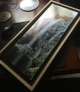
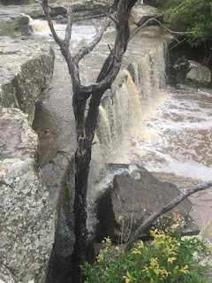
Raggeds Falls, Molonglo River, Crown Land, Captains Flat
The Molonglo River winds through a deep gorge above the old mining town of Captains Flat. Before emptying into the town's large water supply dam, the river plunges over a medium-sized granite wall inside a surprisingly angular amphitheater. At the base of the falls is a cool swimming hole. While the waterfall has not been officially named, a rock in sight of the falls bears memorial to a local miner nicknamed Ragged.
It might be imagined that this is a place where miners would walk to swim after work - so a name reflecting that use seems not out of place. Nearby there are signs that this place was used as a stone workshop by the First People, but I have found no record of their naming of the place.
From spring to early summer, this is a place of wildflowers, including large displays of orchids. The rocky gorge around the falls plays host to lots of lizards (and probably snakes - a good reason to stay on path).
It is a good place to come with a friend - to sit, listen and make memories.
Location Map
There are a number of falls near the town of Captains Flat (and on the nearby Yandyguinula and Jerrabattgulla Creeks), but this is the closest accessible fall. Be prepared for steep grades if you choose to trek down to the Access to the Molonglo River viewpoint shown (this is an optional side trip).
Crown land above the town's dam is crisscrossed by unmaintained roads and tracks that should be scouted on foot before risking a car. Better still, the path in can be walked. In town, a tourist map gives an approximate location for the falls - don't rely on it - you may end up spending many hours hunting up and down the gorge for the falls.
This is #2 in a series of Lost Falls of South Eastern Australia - the Index Page is here
Later visits can be found here.


.jpg)


Comments
Beautiful photos.
Just wondering about the miners memorial
Is it close to the falls. And is it an engraving or a metal plate of sorts. Also the sharpening grooves in the rocks, are they easy to find?
Any info to help find these interesting places would be appreciated.
Gary lynch.