Murrumbidgee Basin (South West New South Wales)

The Murrumbidgee and its principal tributary the Molonglo twist and turn before running west into the barren flat interior of the country. In the highlands, the system embraces Western Falls of the Murrumbidgee River (the lower Tidbinbilla Mountains, the higher Brindabellas - the ACT Alps) and Eastern Falls of the Molonglo River (Black Range and the Great Dividing Range in the Tallaganda).
WESTERN FALLS (Murrumbidgee River)
Ginini Falls (from Mt Franklin, Brindabella Mountains)
Ginini Falls are said to be the highest and most inaccessible waterfall in the Australian Capital Territory, with estimates of its drop ranging from 140m to 220m. It is sometimes described as 'spectacular' (often by those who have never seen it).
Ginini is a multilayered fall tumbling through partially obscured and very steep terrain (with the added disincentive of some of the sharpest undergrowth and steep/fragile cliffs in the country).


The first detailed public report of the falls came from John Gale, a Queanbeyan newspaperman and an enthusiastic proponent of placing the Australian National Capital on the shores of Lake George (which inconveniently dried up during the selection process, leading to the capital being moved to the present site of Canberra on the banks of the Mononglo River (fed by the Yandyguinula) close to the intersection with the Murrumbidgee River.
Gale's party of two almost perished in the attempt, surviving on the chance kill of a lyre bird. His sighting of the fall should act a cautionary restraint on adventure here - despite climbing to the edge, he saw little of the fall. His companion saw more by climbing a tree dangling over the abyss.
Enthusiasts seeking the Ginini followed at different stages, including an ill-fated attempt by a group of young Victorian public servants helping to establish the new capital.
As with many mountain falls, it is difficult to get a clear view of the falls when you are standing in the water itself (a mistake i have made a couple of times). There are a handful of these images, perhaps reflecting the difficulty encountered by adventurers. The best 'point of view' shots tend to be from hikes into the wilderness to the falls and weirs collected by the ACT bushwalker John Evans who also includes trail maps and cautionary tales (on one trip his camera was stolen by some of the sharp bushes along the track).
While circumstances change from time to time, at present there are relatively good views to be had of the top of the fall from the vantage of nearby Mount Franklin - on the walking trail to the summit. Just below the summit (1650m) on Mt Franklin, at an extensive granite platform giving wide panoramic views, the fall can be seen on the slopes of Mount Ginini at 160 degrees South East. The best views are perhaps a little further below this point. Above the falls, to the right, can be seen the amazing Ginini Flats sphagnum wetland which feeds the falls.

I thank my friend Jack who remembered to bring a Nikon 38X camera along on one of our first hikes to the top of Mt Franklin and Indy for her frequent saves.
During the climbs, we have taken about 1200 shots of the falls including an hour of video from a range of different vantages, concentrating on full fall images. It will take some time to process all of these images :/ By way of preview, here are two shots @ 5kms with an angular separation of 2.5 degrees.


Bramina Creek Falls (Goodradigbee River – Brindabella Valley)


Adelong Creek Cascades (Adelong)


Micalong Creek Falls


Gibraltar Falls (Cotter, Tidbinbilla Mountains)
The fall is near Canberra close to the Corin Road. This is the largest accessible waterfall in the Australian Capital Territory. It consists of a series of cascade with one large drop. It has a permanent flow and hosts plants and animal communities not found elsewhere. Bogong moths over-summer here before descending like a blanket for a couple of days each year over the nearby city of Canberra and the Western mountain ranges.
Main Cascade


Lower Cascades


Upper cascades

Wierd Weir

Access (✅), Visible (✅), Pristine (✅), Safety (✅), Spectacle (✅): Aggregate: ✪✪✪✪✪
Kangaroo Creek Falls (Cotter, Tidbinbilla)
This is an inaccessible set of cascades on the Kangaroo Creek near the Corin Dam. Heavy undergrowth makes direct access from roads impossible, leaving only the prospect of walking up the creek.


Access (❌), Visible (❌), Pristine (✅), Safety (❌), Spectacle (❌): Aggregate: ✪
Mountain Creek Cascade
Mountain Creek falls into the wet forests of the Brindabella Range. This little valley is fairly close to Canberra, but it has some beautiful cascades and wetland forests. At the bottom of the cascade is a couple of deep pools with all sorts of wildlife, including a platypus family.
This is typical of the smaller mountain falls, which are largely inaccessible in deep overgrown gorges. There are a couple of different ferns in the picture, the larger are an Australian native which can grown high over farm land in cooler parts of the country.

Access (✅), Visible (✅), Pristine (✅), Safety (✅), Spectacle (❌): Aggregate: ✪✪✪✪
Paddys River Cascades - Australian Capital Territory
Wandering the high country today, looking for lost waterfalls i met a tired park ranger who told me that many of the public parks are being closed, as recent rain and high winds has increased the risk of tree collapse, before returning to the task of dealing with trees across a nearby road.
This picture confuses me. Why is the wind not uniform? why have the dead trees persisted? Why the water stain on the large rock? Why the shape of the waves in the river? But it is also calming, for i do not need to answer any of those questions :)
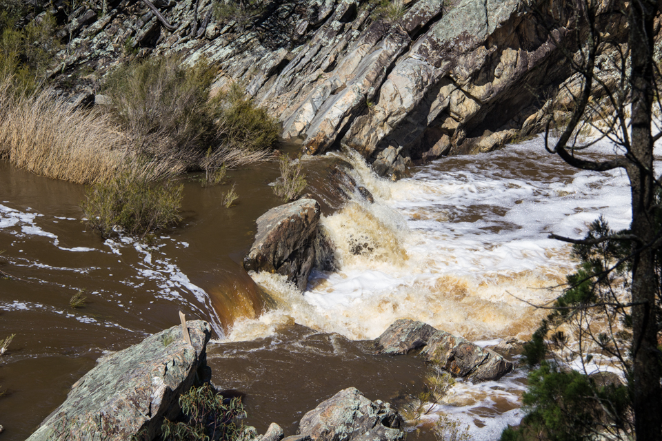
Murrumbidgee Cascades: Uriarra
In between the folds of the hills runs the Murrumbidgee River. Here a single lone dead gum - burnt in the fire storm a decade ago, that devastated this area, its farms, vegetation and wildlife. I found it very hard to come back here after the firestorm - but it is slowly getting easier.
I love this river - it is always unpredictable. I used to travel each day to work across this crossing - stopping on a summer afternoon to swim in the River.


Kayaking through the Murrumbidgee Gorge from the river beach at Casuarina Sands to its junction with the Molonglo at Uriarra is a terrific 8 hour ride. It is only 7km but there are a number of ports and lots of runs. Enough time to get 2nd degree burns.
Each trip i have made has been magical. The river is different ever time – sometimes we have to port boats between rapids – sometimes the river crashes high around us the whole way.
My last trip was a bit of a disaster. Some of the kayaks didn’t make it home... and all the support craft sank and the electrical equipment (phones, cameras) might have got a little wet, and the picnic disappeared. But we still made it back, although it was a couple of hours later than expected. Ok, a lot later, in the dark, but just before the support crew rang for help.

These days no one will come kayaking with me on account of stories of past disasters. I think that the biggest danger in the river are the tree roots and flash flooding. I am always very careful in white water, and recently switched from a traditional kayak to an open deck (sea) kayak to help reduce risk on this section.
Once, I came down to this very set of rapids, with a friend of mine after a long days paddle. We were both completely exhausted and starting to dream of a good meal and a drink of something other than river water. To our amazement, at this very place, there were 15 or more mermaids. I cannot remember the precise number because i was thrown out of my kayak and ended up swimming, under water, until we passed them.
My friend and I only briefly discussed this matter. He told me that they were quite real, and that they politely answered his cheery hellos, and that he did not understand it either.
When I come back to this place, i always check for mermaids. But, so far without any luck.

The red roots of the native casurarina forests line the banks of a wilderness area of this large cascade-filled Australian river. Cascades occur regularly at pinch points along the river's path: making it a fun place to kayak, swim or simply rest by the rushing water.

Downstream are the deep gorges and striking red granite of Woodstock Reserve, with riparian paths into the steep falls of the side streams, with falls.
I think value this place just a little more, because it still wears its first people name. Colonials heard of the river a couple of years before they found it, and by the time of the first sighting it had achieved some notoriety (as in December 1820 a party sent to find the river broke up in acrimony, with one of the members saying publicly that the river was imaginary).


Once, I came down to this very set of rapids, with a friend of mine after a long days paddle. We were both completely exhausted and starting to dream of a good meal and a drink of something other than river water. To our amazement, at this very place, there were 15 or more mermaids. I cannot remember the precise number because i was thrown out of my kayak and ended up swimming, under water, until we passed them.
My friend and I only briefly discussed this matter. He told me that they were quite real, and that they politely answered his cheery hellos, and that he did not understand it either.

The red roots of the native casurarina forests line the banks of a wilderness area of this large cascade-filled Australian river. Cascades occur regularly at pinch points along the river's path: making it a fun place to kayak, swim or simply rest by the rushing water.

Downstream are the deep gorges and striking red granite of Woodstock Reserve, with riparian paths into the steep falls of the side streams, with falls.
I think value this place just a little more, because it still wears its first people name. Colonials heard of the river a couple of years before they found it, and by the time of the first sighting it had achieved some notoriety (as in December 1820 a party sent to find the river broke up in acrimony, with one of the members saying publicly that the river was imaginary).


EASTERN FALLS (Molonglo System)

Raggeds Falls, Molonglo River (Crown Land, Captains Flat)

The Molonglo River winds through a deep gorge above the old mining town of Captains Flat. Before emptying into the town's large water supply dam, the river plunges over a medium-sized granite wall inside a surprisingly angular amphitheater. At the base of the falls is a cool swimming hole. While the waterfall has not been officially named, a rock in sight of the falls bears memorial to a local miner nicknamed Ragged.


It might be imagined that this is a place where miners would walk to swim after work - so a name reflecting that use seems not out of place. Nearby there are signs that this place was used as a stone workshop by the First People, but I have found no record of their naming of the place.


From spring to early summer, this is a place of wildflowers, including large displays of orchids. The rocky gorge around the falls plays host to lots of lizards (and probably snakes - a good reason to stay on path).

It is a good place to come with a friend - to sit, listen and make memories.
Location Map
There are a number of falls near the town of Captains Flat (and on the nearby Yandyguinula and Jerrabattgulla Creeks), but this is the closest accessible fall. Be prepared for steep grades if you choose to trek down to the Access to the Molonglo River viewpoint shown (this is an optional side trip).
Crown land above the town's dam is crisscrossed by unmaintained roads and tracks that should be scouted on foot before risking a car. Better still, the path in can be walked. In town, a tourist map gives an approximate location for the falls - don't rely on it - you may end up spending many hours hunting up and down the gorge for the falls.

Yandyguinula Cascades (Rossi, the Tallaganda)
Mountain Gully Creek Falls


The waterfall here drops over Boro granites (pink-grey in color, often embedding quartz) to an abandoned line of road cut by stonework and a pipe. I climbed up the right side of the fall, but was initially pushed back by rain and lack of purchase.


Scattered near the falls are a wealth of orchids from Diuris in spring to Dipodium and Eriochilus later.


I have found half a dozen places like this along this stretch of the creek, but only the one where i can physically enter. I guess they come and go as these small creeks are constantly being reshaped. The Marble Arch, a larger version, lies at the bottom of a V shaped valley about 30 minutes drive and 4 hours walk from me. Similar, yet without the shaped spheres on the floor. Two other creek shaped non-commercial caves at Wee Jasper and Borenore have massive cave systems attached to them, but as 19th century curios, anything that might be carried away has been :)


Pipe Clay Falls
Clay to produce pigments for ceremonial purposes has been mined from the upper reaches of the Yandyguinula (and further south from the lower banks of the Genoa) from time beyond reckoning. Colonials also mined small quantities to produce smoking pipes.

White Wombat Falls

Mugga (Tiger Snake) Falls

Hobson (1897)
"Last year an ancient Blue Mountains aboriginal, Billy Lynch, told me that his people were skilled in the treatment of snake bite, and in the old days he had never known one of them killed by it. When a native was bitten his companion hurried him to water, placed him in it, left the wound alone, but sucked hard over the heart, and in a very short time declared him free of danger.
The Illawarra natives evidently did not possess this skill, as, according to Mr Brown, they were sorely afraid of snakes. When bitten they scarified and sucked the wound. He never knew one die of snake bite, however, though they were said to lose their sight as a result of it. Perhaps some superstition had to do with their fear, for they were generally fearsome of the unknown - so are most men for that matter."

Galvins Creek Cascades


In kinder times, the City was home to two fascinating men – both holding the title of Comte de Rossi.
The early career of Francis Nicholas Rossi (1776-1851) is almost unbelievable. At the age of 19, after he lent support to the British occupation of Corsica, he lost all his possessions when France retook the island. He joined the British army, serving with credit in Holland and Gibraltar, and then transferring to Ceylon and Mauritius as Captain, in charge of Indian convicts. In 1819, it is rumored that he played a pivotal part in obtaining evidence for the royal divorce – a scandal that shook England at the time. In 1824, he transferred to the Colony of New South Wales to take up the position of Superintendent of Police (and magistrate) and worked for 10 years on the reorganization of the force along the lines of the British Bow Street model. In later years, he retired to his property at Goulburn. After leaving Corsica, he overcame a number of disadvantages - his foreign status, accent and poor knowledge of English law – to become an important pioneer in the colony. Today, that work is recognised by a number of locations that bear his name and a plaque that almost brought down the Saint Saviour's Cathedral.
His son, Francis Robert Louis Rossi (1823 – 1903), took a legal career early in life – becoming the first Superintendent of Police in the Monaro, and building an iron bark slab homestead called Micilago (the area to the south of Canberra is now known as Michelago). In 1851 he took charge of his father’s Goulburn property and became, first, a local magistrate and then, in 1870, the Registrar of the District Court at Goulburn. Over time, he became trustee for most of the local Church of England property. Disputes arose with the establishment of the Goulburn Cathedral. During a bitter ten year legal dispute (1884-94), Rossi was slowly drawn into the problems and eventually took a leading role in the conflict. It was finally settled against him in the Supreme Court.
During the dispute, in 1887 he took a plaque in memory of his father into the new Cathedral and kept armed guard over it. When it was removed in 1891, he reoccupied the cathedral with a band of men and remained in occupation for some time.


St Saviour’s Cathedral itself is one of the finest white sandstone cathedrals in the southern hemisphere – and the only 12-bell country peal there.
Today Rossi’s plaque can be found embedded in the Cathedral wall. The church itself is an impressive building, but one of the volunteer guides tells me that it has again fallen on hard times, attracting few parishioners save on special occasions. Politely she turned the conversation around to the possibility of me coming along to boost the numbers a little, perhaps to sing. While I have a fine voice, I don’t think she would approve my choice of song.
An old friend, Justice Rae Else-Mitchell, took me to lunch when he heard I had moved to the Molonglo High Plains a while back. He and I had worked closely in the early days of the establishment of the Australian Capital Territory – his office was a couple of doors down from mine, and we spent many hours arguing and working through the problems that beset the new polity. He was passionate about history, and in view of my recent move into a district with a small forestry village called 'Rossi', at our lunch he spent the afternoon telling me the above stories of the two Comtes. He died in 2006 at 91.
Molonglo River Gorge Falls

In dry times, crystal clear water gently flows through the lengthy gorge. In flood, it becomes a long cascade of silt laden chaos.
Molonglo Gorge is an ancient pathway through the mountains. After rain, the waterfalls and cascades flow strongly. A path follows the banks of the Molonglo River through the gorge, but the path rises and falls to avoid great river boulders and cliffs.

While the cascades are very close to Australia’s capital city, Canberra, the gorge is seldom visited. This is perhaps because the waterfalls and cascades are largely inaccessible and can only be viewed from a distance. The noise of the waterfalls can be very loud and the air full of water spray. Most waterfalls I explore are too dangerous to swim near. This place is full of ‘human-sized’ waterfalls: when the river slows, the waterholes are gentle places of healing. There is something in the sound of a waterfall: it takes you away from the world. After very heavy local rain, the muddy river will submerge the river path. Fortunately it is possible to climb to the top of the gorge and rejoin the track about 1km along via a steep shale path. At this point, the river does two 100+ degree turns, creating the curved walls of the amphitheater, which in calmer times has a couple of nice swimming holes (it would be silly to try swimming with any force of water).
Lower Cascades
The hiker into the Gorge starts downstream, at the end of the waterfalls. At first, the lower path follows the river.

A short walk will take you to the first pinch point and on to a natural wonder of the Gorge, Turtle Rok - an overhanging rock in the shape of a short-necked turtle (although you are more likely to find the small Eastern Long-Necked Turtle in the Gorge).

In summer the pools offer a cool respite from the heat, but water levels here can rise suddenly from local storms in the mountains to the east.
After the first set of pools, the Lower Track leaves river level and gradually climbs to the top of the gorge to avoid the steep drops encountered deeper in the gorge. I once met a couple of photographers on the track who asked how to get to the waterfalls in the Gorge. I swim out to a rocky ledge (making sure my camera gear is in water and shock-proof bags, and then rock hop over to a closer vantage point. The rocks exposed to water have the softest curves, and are very slippery even when dry. In winter, this is dangerous, as some of the river is in permanent shadow, and the rocks are covered in black ice.
Each fall is different and some are practically inaccessible - it is best to bring a zoom lens.

This is a great place to come cool off mid-summer. There are long deep pools for swimming between each of the waterfall clusters as well. The wildflowers are something to see if you get there early enough. The fall of water is something we understand intuitively and to see it in a natural setting is comforting. The setting of this first fall is intimate and as I look at it, I see integrity in the natural structure. This small waterfall is in proportion and harmony with the rocks around it. And then there is the brightness and clarity of the water itself. Some say that beauty can only be found where there is also utility. I am not sure of this, although I can imagine people swimming here to avoid summer heat or simply enjoying the day.
Ratings are given for the entire gorge:
Access (✅), Visible (✅), Pristine (✅), Safety (✅), Spectacle (✅): Aggregate: ✪✪✪✪✪
Amphitheatre Falls
Midway into the gorge is a chute waterfall, where a pinch in the Gorge has created a long narrow sluice. At the end of the chute, a waterfall fans out into a waterhole for summer swimming.
After heavy rain, water enters the scene with great force. The height of the water at the start of the sluice can be gauged from the overflow waterfall a little further along.

A natural amphitheater curves around the river at this point. In summer, the pools under the permanent waterfalls are great places to swim and relax. In flood, the river is dangerous and unpredictable with river speed and turbulence highest in the first couple hundred paces of the base of each river fall (which occur approximate 500 paces apart).
Cerberus Cascade
Crystal clear water plunges through this lengthy run.

Coffee and Cream Falls
Always a little sparky, in times of flood, this fall creates a stir


Gyrus Falls
In the upper reaches of the Cullarin Block, a splatter of water in the form of an upside-down branched candlestick (girandole) or, perhaps, a bombe glacée. Many of the upper waterfalls are inaccessible without ropes and lots of time.
Blue Tiles Cascades
A group of hardy settlers came to live near this place on the Molonglo River more than a century ago, but hard conditions eventually forced them from the area. Today, only their abandoned farms remain, and the pools they once swam in.A little further down the gorge, the waterfalls become higher. Here, near the top pools of the abandoned settlement, the cascades are ‘human-sized’.

Exfoliated/Carved Rock
Flood, sun and rockfall (from natural and railway construction cause) have created curious patterns within the exfoliated rocks. Some are shaped into strange and amazing shapes and some show sign of additional chipping to produce specific forms. It is not known whether the chipping was caused by natural collision, railway construction or human design.


Notes: The names used in this post come from original letters and diaries of European settlers and explorers and, like many features near the National Capital, have no formal recognition. The First People names for the waterholes in the Gorge (names were seldom given to falls) are unknown.
If you are starting your hike into Molonglo Gorge, take the low track if the water level is low and the high path if the river is in flood (the path at Turtle Rock will be under-water and impassible).
If you propose to enter the water to swim, avoid flooded reaches and rapids. Watch for wood debris in rapids (there is a lot of cured willow upstream) and snakes.

By convention, sea breezes that travel inland late afternoon are styled doctors: bringing a blast of humid, colder air with a hint of the sea. The Molonglo Doctor is a regular summer occurrence in the high plains, dropping temperatures 5-10 degrees and cloaking the mountains in mist.
(The original animation I attempted was fast - Admiral LadyPaula Rizzuto suggested slowing down and fading between frames - In Photoshop CC these changes are easy to make in the Timeline menu, using the Tween Tool. It gives the animation a softer and more gentle feel.)
Ancient History
We know a surprising amount about the history of our local region because of core samples from the nearby Lake George Basin.The region emerged from shallow seas more than 150 million years ago. The surrounding mountains resulted from volcanic action from that time and as part of the general uplift of the eastern highlands about 80 million years ago. However, it has changed slowly over the past 50 million years. Against the backdrop of familiar landmarks, climate, vegetation and animal types have gone through a number of distinct stages.
50-30 Million years ago: wet, warm
When the land bridge between Antarctica and Australia finally sank about 50 million years ago, the Yandyguinula valley was a much wetter and warmer place. Like much of the rest of the country (and Antarctica), it was covered in lush rainforests. The Yandyguinula, probably shrouded in perpetual mist and flowing heavily, periodically flooded some of the lower valleys as it cut its way through the dense conifer rainforest.The forest canopy towered up to 50 metres above the ground. It consisted of the Southern Conifers (today, descendants of the northern family include the Kauri, Bunya, Hoop and Norfolk Pines while the southern family, known as Podocarps, include the Huon and Celery-top Pines) and the Southern Beeches ( the Antarctic Beech, Nothofagus moorei, is still found in Queensland rainforests). These trees are very ancient with the Kauri Pine still closely resembling fossil records from 175 million years ago. The Beeches spread to this country across Antarctica from South America about 90 million years ago.
In the understorey were ferns, cushion plants, rhododendrons, orchids, hollies, ancestors of the willows and the gums. Leopard -like Wakeleo stalked the forests with Tasmanian tigers and carnivorous kangaroos. Large toothed platypus, possums, numbats and bilbies lived in the forest.
From this and earlier periods, remnant species still survive in our region.
30- 5 Million years ago: drier, colder
About 30 million years ago, Antarctica drifted lower to the south pole and world temperatures began to drop. The sea level fell, temperatures began to drop and Australia began to dry. The great Pine forests began to retreat to the Eastern seaboard. Casuarinas (probably developing from early willows) slowly replaced the Southern Conifers in the new dry woodlands, while gum trees thrived in the drier climate. As more extensive grasslands developed and the forests became more open, large marsupial browsers and flightless birds appeared. It was a time of giant marsupial browsers including the bear sized Nehelos and the Diprotodon.The north-south Lake George Fault began to slowly rise during this period. Over 20 million years, it rose about 100 metres, impeding the westward flow of both the Yass, Molonglo and Yandyguinula Rivers. The Yass River, with a small catchment, was not able to cut through the new range and pooled into Lake George. The Molonglo, helped in part by the Yandyguinula, cut through the range near Balcombe Hill. During the periodic ice ages at times of very low rainfall, even the Molonglo failed to keep up with the gradual rise along the fault. At these times of drought, the Molonglo formed a lake on the Hoskingtown Plain.
5 Million Years Ago
About 5 million years ago, the Lake George Fault ceased to rise. This coincided with another dramatic ice age. The Molonglo drained through the fault and the plain started to dry out. By this stage, the forests in the region consisted of a mix of casuarina canopy with a fern and podocarp understorey (on the higher peaks in the ACT the mountain plum pine (Podocarpus lawrencei) still clings to rocks). The forests survived in the mountains and hills, extending onto the plains during periods between ice ages (there have been 20 ice ages in the past 2 million years). During colder, drier periods, the plains became open forests and grasslands.
100,000-180 years ago: fire stick agriculture
To the north of Lake George, in sandstone, is the footprint of one of the giant marsupial browsers. Next to it is the footprint of a man.When aborigines settled the continent, they brought with them knowledge of fire stick agriculture, which they used as an integral part of hunting and everyday life. The introduction of systematic burning co-incided with the extinction of many of the forest casuarinas and podocarps (although it is not certain whether these are related or are both aspects of a different event as yet undiscovered). The forests were replaced by grasslands and eucalypts and the Casuarinas and podocarps “retreated” into the wetter mountains.
The intensity of aboriginal occupation probably varied with climatic factors. During ice ages, traces of carbon in the fossil record become rare in the face of the permanent snow which settled on the Great Divide and the Black Ranges. During warmer interglacial periods, fire stick agriculture returned to the plains and foothills, but only rarely was felt in the wetter ranges. As the next fire tolerant range of species became widespread in the lower and mid ranges, remnants of the Casuarina forests held fast to the river banks or joined earlier remnant species in the high wetter valleys and ridges of the ranges.
About 30,000 years ago the last of the giant marsupial browsers became extinct and the last of the Tasmanian tigers retreated permanently from this area. The region was left to the grey kangaroo, the red-necked wallaby, the koala and a range of smaller marsupials including the native cat and the possum. Bush turkeys led mostly solitary lives while quail and emu lived in large family groups.
The Yandyguinula and Molonglo were a series of marshy ponds. Protected by stands of casuarina and tea tree the ponds were a haven for ducks and swans. During warmer periods, brolga from the interior may have lived on the river (but there is doubt about whether this continued into modern times).
Along the river stretched the permanent grassed walking tracks of the aborigines. Early settlers found these trails kept free of obstruction and well burnt. Of necessity, the trails were used by the first shepherds, adopted by the settlers and mapped by the surveyors. Today, our roads follow those same trails.
180 years ago to present
The first three white Australians to ride across the Hoskingtown Plain in the 1820’s were all native born “cornstalks”, selected by Governor Macquarie. The young men had no difficulty communicating with the aboriginal people they met and reported back to Sydney about a rich environment. They also reported seeing numerous fires of the aboriginal inhabitants of the five high plains in the Hoskingtown, Queanbeyan and Canberra regions. However, within a decade, aboriginal people from the region had withdrawn to the central Canberra plains and the Tidbinbillas and encounters with aborigines living traditional lives became infrequent.With the cessation of fire stick agriculture, the Eucalypt and Acacia populations exploded. Within a decade, the tended woodlands of the aborigines became impenetrable scrub. Resourceful foresters logged many of the mountain giants. The casuarinas along the river were removed for fencing and yards. Rumours of gold led to the declaration of gold reserves along the rivers. The wetlands disappeared and the banks of creeks and rivers became sharply delineated through erosion. Koalas and bush turkeys were shot out for sport and tucker.
Attempts to plant orchards, run dairies and intensively farm small selections were frustrated by years of drought and the loss of settlers to flood, influenza and war. Farms further away from permanent water were abandoned. Presently, many survive only as collections of hearth stones and isolated stands of exotic trees, but the region is starting to repopulate.
Return to Waterfall Page

Date Published: 2019-02-24
Date Last Revised: 2019-03-22


Comments