Hell Hole Falls, Parma Creek, Parma Nature Reserve, Nowra


Hell Hole is a bottleneck canyon which starts near the top of Parma Creek.

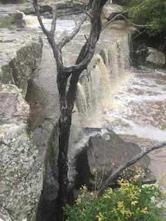
The Parma Creek drops more than 200m through a quartzose sandstone gorge to meet the Currambene Creek and thence into the sea. As the Parma Creek has twisted and turned through the canyon, following a monocline's fold, it has eroded siltstone walls lying between an upper and a lower sandstone layer. There are a number of falls along this canyon (and along the tributary Flat Rock Creek) before one large final fall at the Parma/Currambene Basin


Erosion through the upper layer of sandstone creates distinctive holes in the creek bed. The siltstone layer between the upper and lower sandstone layers can be eroded up to 15m in depth. The erosion has, over millennia, led to the downstream collapse of the top layer of sandstone into the underground stream. Over time, the resulting waterfalls have slowly moved up the creek, as new underground caverns have been cut away. By this means, a deep gorge has gradually been created, in fits and starts.

It is possible that early sawyers or masons named the area.
Like many southern coastal areas, the first colonials were sawyers who searched for and cut the large turpentine eucalypts growing on the rich siltstone soils. Fewer large trees prospered on the top sandstone cover, which supports little but heath and grasses. Siltstone forms deep rich soils, and sawyers keenly sought the trees on this soil. Sawyers may have named the location after encountering the deep eroded holes, which collect debris - including bones - washed into the creek. The siltstone contains fossil brachiopods - another possible trigger for the name. Finally, the stream can run and disappear into some of the larger holes. These holes can be death traps to both the unlucky or the incautious.
Stonemasons were attracted to the sandstone and the underlying siltstone, which was cut in deep quarries for road and building purposes, or collected for farming. A deep quarry to the east of the waterfalls might also have suggested the name, as masons of the time informally named quarries according to a quarry's shape - sometimes choosing the name "Hell Hole" to signify a particularly deep and dangerous quarry.
It is possible that an early farm in the area also adopted the name, perhaps from two other natural conjunctions in play. The heath Mountain Devil (Lambertia formosa), so named because after its bright red flowers fade, a horned seed appears, is a bush that thrives on the sandstone surrounds. The area hosts a superb number of wildflowers, even in mid summer.


Flannel flowers were in full bloom here and higher on the Tianjara escarpment.

The sandstone of the gorge best supports heath vegetation - and that is significantly impacted from periodic fires, most recently in 2019-20. However, the microclimate created by the falls creates a rich environment for rock orchids and ferns.


The startling Red Devil Cicada, so named because of its large size, piercing call, and bright red eyes, also thrives along the creek and can make dramatic appearances in late spring.

The creek is home to a vast range of creatures, including the heath frog, hawk moth and, the less often seen, marijuana grower. A bushwalker group reported finding a crop of weed "... in an area beyond the waterfall on the Hell Hole walk. It was well set up - a covered hammock, washing and socks hanging, plenty of tools and plants. I couldn't get away quickly enough, perhaps someone was not too far away!" We didn't catch sight of the latter on the most recent journey.


Location
I travelled to these falls with my gym instructor Indya. The adventure will require a fair fitness level.
Travel to the Turpentine Road (tarred) and turn onto Hell Hole Trail. The trail was in fairly good condition when we travelled there recently but it can deteriorate quickly. If you are in a 2WD, park here and walk in. Just before the trail crosses the Parma Creek, you will see a highly degraded trail to the right. Don't attempt to drive down. Walk (carefully, as the clay surface can be unexpectedly slippery).

While you will walk to the end of the track, part way along is an obvious track to the left down to the creek. Take time to look at the pot holes in the river, taking care not to accidently step into one. Do not intentionally enter any of these as some have dangerous suction outlets at the bottom while others can host snakes having a doze. These holes are known killers.
At the end of the main track, you will see the top of the falls to your left. At the top of the falls (avoiding the edge - which is fragile in places), carefully cross over the creek to the north side (don't try this if the water is running hard). While crossing, note the break in the sandstone parallel to the fall edge. Remember this break when you are sitting under the sandstone overhand below.

Once across the creek follow an indistinct path around the side of and then down the fall wall. You will find yourself in a short slot, which will take you to the overhang cave below the falls.

Parma Creek has a shallow catchment - the falls may not be running unless there has been recent rain - which will make traversing the creek slippery. Do not enter the creek if it is running fast.


There are a number of other falls nearby, including the unique basin falls at the Falls Creek Picnic area, and further downstream.
This is #6 in a series of Lost Falls of South Eastern Australia - the Index Page is here
Or come visit my index to the Waterfalls of South Eastern Australia.


Comments
Having had a couple of bad falls in and around waterfalls, i am cautious about referring people to more difficult trails. Even well signposted trails with well formed steps and rails can be a trap - a year ago i chanced upon an elderly tourist having a heart attack on a well-known by steep Victoria fall.
I grant you that dresses are probably more a nineteenth century waterfall fashion - but then, Indy is not an ordinary gym instructor :)
Cheers
Cheers, Emma
You are very close. You have turned off to the south side of Turpentine Road - you want to be on the north side. I have added another general location map at the end of the article to help (with the rain over the next couple of days, the creeks there will be really gushing)
Stay safe, Peter