Lachlan Basin Falls (Central South-West Slopes)
The Lachlan is a major inland river.
The system takes water from every passing rise, but fades into desert or marsh. The explorer Oxley contrasted the Lachlan with the more northerly Macquarie River, saying it "... is constantly diffusing and extenuating the waters it originally receives over low and barren deserts, creating only wet flats and uninhabitable morasses and during its protracted and sinuous course is never indebted to a single tributary stream." (Journals of Two Expeditions in the Interior of New South Wales By John Oxley)
While there is no large single tributary, smaller tributaries drain the dry western reaches of the the Great Dividing Range from Orange to Goulburn and, today, snow and flood water is impounded in a number of dams and slowly released for irrigation on the Lachlan. These small tributaries also drain a number of isolated ranges on the western slopes, including Mount Canobolas, Mount Arthur, Mount Nangar, and Weddin Mountains. These rocky mountains sport spectacular falls although most only flow after local rain and many are inaccessible
A real-time view of water flow in the system can be found here.


Access (✅), Visible (✅), Pristine (✅), Safety (❌), Spectacle (✅): Aggregate: ✪✪✪✪


Access (✅), Visible (✅), Pristine (❌), Safety (✅), Spectacle (❌): Aggregate: ✪✪✪
The photographer Lumme in 1900 photographed a number of waterfalls around Cowra, Mandurama, Lindhurst and the mining areas know as Junction Reefs.
The waterfalls along the Belubula gorge can be accessed along the river and, in particular, at Bakers Shaft Reserve. Nearby, the Junction Reef Dam is now silted up, but may be one of the places in the Lumme photos.
The Belubula may also host Swamp Falls and Bay Falls - referred to in local diaries and reports.
 |
| Federal Falls, Boree Creek, Mount Canobolas |
While there is no large single tributary, smaller tributaries drain the dry western reaches of the the Great Dividing Range from Orange to Goulburn and, today, snow and flood water is impounded in a number of dams and slowly released for irrigation on the Lachlan. These small tributaries also drain a number of isolated ranges on the western slopes, including Mount Canobolas, Mount Arthur, Mount Nangar, and Weddin Mountains. These rocky mountains sport spectacular falls although most only flow after local rain and many are inaccessible
A real-time view of water flow in the system can be found here.
Northern Tributaries: Boree, Terrara, Balubula
An indication of the flow of these falls can be obtained by examining the Mandagery Creek flow at Eugowra or checking the flow of the Boree Creek at the Borenore Karst Reserve in person.
Federal Falls
There are a number of plunge falls on the western slopes of the old volcano Canobolas. While some distance inland, Mount Canobolas is high. It keeps visitors guessing. It can be summer down on the plains below but blowing a blizzard up top. Or it may be hot as Hades. Be prepared.
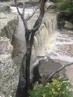
The largest fall on Boree Creek is Federal Fall. The main plunge is the first in a series of drops, with a cave behind the base of the falls. Both base and top of falls is accessible. The falls are a fairly long walk from the car park near the summit of Mount Canobolas.
The creek can become a trickle in hot dry weather. There is a far closer marked road (the Federal Falls Road) which appears to be at the top of a series of Forestry tracks. I have followed this way in but as the track becomes steep and rough.
Federal Falls has a couple of unusual qualities. In winter it can be slightly periodic - the flow waxing and waning depending on the influence of the wind and frost melt on the upper creek. It does not have a deep plunge pool at its base, suggesting the fall is cutting up the valley fairly quickly. Finally, it has a cave at the base. Caves behind a waterfall are much more romantic from a distance. Up close they tend to be full of mozzies and smell like old washing machines.
Unlike the unique falls on the eastern side of Canobolas destroyed by mining companies, Federal Falls is safe, for now, although there has been talk of flooding lower areas to create ample water for miners planning new works to the west.
I travel to Orange frequently and love coming back to these places. The walk is worth it (as are the walks to the nearby volcanic plugs - and nearby the Borenore Karst, also formed by Boree Creek).
 |
| Federal Falls, Boree Creek, Mount Canobolas |
The largest fall on Boree Creek is Federal Fall. The main plunge is the first in a series of drops, with a cave behind the base of the falls. Both base and top of falls is accessible. The falls are a fairly long walk from the car park near the summit of Mount Canobolas.
 |
| Mount Canobolas |
The creek can become a trickle in hot dry weather. There is a far closer marked road (the Federal Falls Road) which appears to be at the top of a series of Forestry tracks. I have followed this way in but as the track becomes steep and rough.
Federal Falls has a couple of unusual qualities. In winter it can be slightly periodic - the flow waxing and waning depending on the influence of the wind and frost melt on the upper creek. It does not have a deep plunge pool at its base, suggesting the fall is cutting up the valley fairly quickly. Finally, it has a cave at the base. Caves behind a waterfall are much more romantic from a distance. Up close they tend to be full of mozzies and smell like old washing machines.
Unlike the unique falls on the eastern side of Canobolas destroyed by mining companies, Federal Falls is safe, for now, although there has been talk of flooding lower areas to create ample water for miners planning new works to the west.
I was born on the edge of the western deserts and didn't see a hill until i started school. However, i spent the last couple years of school life exploring Mount Canobolas and the nearby caves at Borenore (near Orange in central New South Wales). Once you get the hang of hills, it is difficult to go back to the flat lands. Hills are as exciting as being on top of a haystack with a girl who kissed you yesterday. And just as dangerous and unforgiving.
I travel to Orange frequently and love coming back to these places. The walk is worth it (as are the walks to the nearby volcanic plugs - and nearby the Borenore Karst, also formed by Boree Creek).


Access (✅), Visible (✅), Pristine (✅), Safety (❌), Spectacle (✅): Aggregate: ✪✪✪✪
Baluluba
A number of the falls on Eastern Canobolas, now lost to us by mining, were described by the first Geological Surveyor of NSW, Samuel Stutchbury, in 1851:
“In a gully or creek called the Waterfall, running into the Cadiangullong or Oaky Creek..., and at the extremity of a mountain spur known as the Rocky Range, there is an immense mass of oxydulous iron, forming in one solid mass a precipitous waterfall of about 60 feet in height. In this mass of iron, especially in the joints, there is brilliant crystallised iron pyrites, with small quantity of yellow copper ore, and traces of blue and green carbonates of copper. A few yards below the waterfall large masses of yellow ochreous iron ‘gossan’ occur in the banks and bed of the creek. This gossan contains a considerable quantity of earthy green carbonate of copper, also plush-like malachite. Upon sinking a short distance into it on the eastern side, a rich lode of grey sulphuret of copper was found. In traversing the creek southwards numerous indications of other lodes were visible, together with large masses of mundic.”The waterfall must have been a magnificent site, before it was destroyed for the copper.

The falls of the mid-Balubula are the subject of a separate article: Here.

I am presently exploring the falls of the eastern Lachlan catchment (Frogmore and Mt Darling). They are the subject of a separate article: Here.
Terrara Creek: Dripping Rock Fall
Further out west is the impressive escarpment around Mount Nangar near Eugowra. This is a dry and unforgiving place: the local community abandoned it after decades of drought and fire. Still, after rain, the escarpment will come alive with waterfalls.


Terrara Creek hosts a waterfall known as Dripping Rock Falls- so named because it seldom runs, although it will continue to ooze water (although it was hard to see any water in the 2019 drought).


After sustained rain, a number of creeks fall from the escarpment, and some can be seen from vantage points along the Mount Nangar trail or from the main road (near the site of a gold robbery and an abandoned homestead.


After sustained rain, a number of creeks fall from the escarpment, and some can be seen from vantage points along the Mount Nangar trail or from the main road (near the site of a gold robbery and an abandoned homestead.

A similarly named creek (Licking Hole Creek) may similarly host a fall in wet conditions.
Access (✅), Visible (✅), Pristine (❌), Safety (✅), Spectacle (❌): Aggregate: ✪✪✪
Middle Tributaries: Belubula and Abercrombie Rivers
Belubula: Coombing Falls, Taffys Falls, Belubula Falls
An indication of the flow of these falls can be obtained by examining the river gauge below Carcoar Dam on the Belubula.The photographer Lumme in 1900 photographed a number of waterfalls around Cowra, Mandurama, Lindhurst and the mining areas know as Junction Reefs.
The waterfalls along the Belubula gorge can be accessed along the river and, in particular, at Bakers Shaft Reserve. Nearby, the Junction Reef Dam is now silted up, but may be one of the places in the Lumme photos.
The Belubula may also host Swamp Falls and Bay Falls - referred to in local diaries and reports.
Abercrombie: Grove Creek Falls
An indication of the flow of these falls can be obtained by examining the Abercrombie River flow near Tuena

This 70m (210') fall carves an impressive cave system before tumbling down to the Abercrombie River. You can still find gold flecks in the creek and one of the old prospectors walking the hills will tell that the first miners into the area found a waterfall faced with the precious metal.

Split leads above the main falls after a downpour
East Australia is in the grip of a drought. This particular area is usually dry (and these falls silent). These shots are after good rain.

'House of Stairs', Upper Falls, Grove Creek

Split leads above the main falls after a downpour
There is a mystery here (apart from the nuggets of gold that might be at the bottom of the pool).
From a distance, the path of the fall and the rock fractures combine to give a lattice effect - that plays tricks on the eye - if you look at the moving sheet of water, the fall looks a little like the scales on a moving snake.
It took a little while, but eventually i found a weathered carving of a snake on the waterfall wall. Can you see it?
The eye gives it away - it cannot be a natural feature. I took shots from a number of vantages - i think (but cant be sure) that the eye is carved and the curve of the body has been deliberately chipped (it deviates from the rock structure).
There is a dream-time story that connects this place with Jenolan and Wombeyan (all places of extensive caves).
The first people traveled across this land, but the rivers and streams were of primary importance to them. The first people were spiritual but practical. The law of the people determined the names of things. The law set how stories could record names. It set out how stories could retell the names in ceremonies. It required newborn children to take the name of the closest named place to birth. A person’s name tied the person to the land.
In the far past, animals claimed the shapes of men and women. They walked the world as giants. Two giants formed the land including Abercrombie, Jenolan and Wombeyan. The serpent fish Gurangatch lived in the deep rivers. From the name you can tell that Gurangatch is big and powerful in water, capable of moving fast. The tiger cat Mirragan lived in the forests camping by the sides of the rivers. From the name, you can tell that Mirragan slides through the shadows of the night forest, deadly silent.
The battle between these two giants scarred the land, leaving waterfalls and deep pools in their wake.
This dream time story is a little different to the Yuin story associated with Tuross Falls.

Reptilian carving in Fall wall
Perhaps the carving is part of the dreaming of Gurangatch and Mirragan :)
Above Wyangala Dam, the Abercrombie hosts a number of falls from the high surrounding gorge and one of which (Alum Falls) may have been photographed by Lumme.
Above Wyangala Dam, the Abercrombie hosts a number of falls from the high surrounding gorge and one of which (Alum Falls) may have been photographed by Lumme.
Access (❌), Visible (✅), Pristine (✅), Safety (✅), Spectacle (✅): Aggregate: ✪✪✪✪
Koorawatha Falls, Bang Bang Creek, NSW
An indication of the flow of these falls can be obtained by examining the gauge on the Crowther at Watervale but this one is always a bit of pot luck.
In midsummer some Australian waterfalls take a break and dream in the hot sun. On the rocks surrounding the path of the multiple falls at this point, it is baking hot. But in the bottomless pool beneath Koorawatha Falls, the water is deliciously cool although it becomes colder as you swim deeper. Lumme reported the name of this fall as Coorowth Falls and it is elsewhere referred to as Bong Bong Falls.

Koorawatha Falls is at a surprising confluence of waterfalls and a deep plunge pool on the Bang Bang Creek near the cherry orchard district of Young. From here on westerly, bush people call rapids in one of the large slow moving rivers a fall. The fall is often dry, allowing the sure footed visitor to explore the cave near the top of the fall.

The right hand side of the fall has a unique 'racing stripe' caused by variations in the pool level, and algal growth.

On another visit the 'racing stripe' may disappear or change position.

The ripple was caused by the toe of young boy who, with his sisters, had walked from their farm to the falls for an adventure - the three of them took me to the best places to take shots of the fall, and then told me all sorts of unbelievable stories about the place while i traded a couple of bottles of water for a muselli bar. I think that the older sister told me that a bushranger once lived in the cave half way up the falls. In the bush, unbelievable stories are always carefully chewed over, because they often turn out to be believable when it is too late.
I trust the stories of old bushmen who sometimes share their experiences of the uncommon with me. In the city it is easy to discount the stories of dark unknown shapes as tricks of the light, a feeble mind or delusion. It is a different matter when you must ride through the dark forests, far from other humans.
The drop-away here under the water is very sudden, and perhaps dangerous for those not confident in water.
Up close to the falls, the markings on the rock face record the pattern of the waterfall as it slowed and then stopped. Almost a 'rock-record' or 'photo' taken by the rock of the path of the falls :


The track to these falls is strictly 4WD with deep ruts and sloping road surfaces. After rain (the best time to see this western waterfall in action) the road is impassable. Park by the side of the creek near a basic weather shelter that lies in ruin, just before the weir. The track to the falls is fairly self evident, but will require a scramble in places. Enjoy the 20 minute walk along the dam to the confluence of the waterfalls and the plunge pool.
Access (❌), Visible (✅), Pristine (❌), Safety (❌), Spectacle (✅): Aggregate: ✪✪
Access (❌), Visible (✅), Pristine (❌), Safety (❌), Spectacle (✅): Aggregate: ✪✪
Gegullalong Falls
Memoirs of one of the original colonial settlers in the Borowa District, Benjamin Morgan (died 1934), hints at the importance of the river system, and falls as important place markers, for the first people.From 1850 to 1866, the greater part of our population consisted of aborigines. There were various tribes and one was known as the 'Burrowa' tribe. An old aborigine once told me that the correct pro- nunciation of the name of their tribe (and incidentally of our town) was 'Burrowong' — it meant a kangaroo run.The (now named) Geegullalong Creek (or nearby Castles Creek or Breakfast Creek) may hold falls in the folds of the rolling hills here - or perhaps this is yet another reference to the Koorawatha Falls.
Most of the time the aborigines roamed about. The Burrowa tribe would travel along GegulIalong Creek to the falls, then along Narra Allen Creek to where it joins the Burrowa River. At that point they would be met by the Cowra blacks; sometimes they would hold a Corroboree, sometimes they would fight.
In those days the blacks were given grey blankets by the Government, and these, the gins wore wrapped around themselves and tied at the waist, either by a strip of bark or kangaroo hide. The right arm was always free, and the piccaninnies were carried on their backs. Often they camped near the stations, but they never gave any trouble. They always travelled along the rivers, the gins going first, laden like packhorses, the men hunting on either side of the river for possums and kangaroos.
Lower Tributaries: Lachlan
An indication of the flow of the river at Forbes (Cotton Falls) can be obtained by examining the gauge on the Lachlan at Cottons Falls
Berthas Gully Falls
In the remote Weddin Mountains, small waterfalls will cascade through gullies after good rain.
Cotton’s Fall
In the river system below the inland city of Forbes, there is nought but flat water and, as a result, it is here that waterfall hunters, kayakers and explorers stop pestering the river. Instead, it is filled with the pumps of irrigators and drowned trees washed into the passage by the occasional flood.
The last fall on the river is named after it's creator: Cotton.

Cotton, an eccentric person, thought that the world could be improved by commonsense and clever ideas. He did not find the river quite as we see it today – back then it was either bone dry or in raging flood. He built a weir here on an old rock shelf, at a fraction of the price government thought possible, and created an oasis around the town of Forbes, one of our large outback cities.
Governments everywhere secretly fear people like Cotton.
Access (✅), Visible (✅), Pristine (❌), Safety (✅), Spectacle (❌): Aggregate: ✪✪✪
Location
The trail to Federal Falls is well signposted.
For Grove Creek, it may be worth getting directions to the fall and vantage points from the Abercrombie Cave House (and visiting the caves while you are there).
Koorawatha Falls is poorly signposted and the meager facilities are poorly maintained. The track in should be avoided in wet weather, and the trails treated very carefully.
Access (✅❌), Visible (✅❌), Pristine (✅❌), Safety (✅❌), Spectacle (✅❌): Aggregate: ✪✪✪✪✪
Return to Waterfall Page

Date Published: 2019-02-24
Date Last Revised: 2019-03-22


Comments