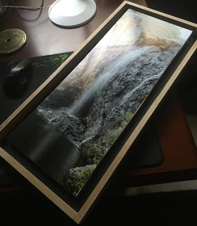
Bocannecals Falls – Mount Darling (orphaned system assoc. Lachlan River system)
Many places never make it onto maps.
On his deathbed in the 1930s, an old farmer repeated a story from the First People about a waterfall that served as a ceremonial meeting place (both peaceful and warlike) between clans in the Boorowa/Cowra region. Following these leads, I have been searching for a significant fall, with features (esp permanent water and food) that might attract largish groups to this remote area. Sadly neither maps, surveyors or the present living can recall the location. Frustratingly, the names used by the farmer have been moved around the map. Some locals have asserted that there are no falls in the area and have kindly suggested i should spend time in local coffee shops or art galleries.
This appears to be the spillway of one of a number of falls in the deep gorges of the fractured folds of the Mount Darling system: here the lower folds being slate and the upper, a crust of hard volcanic origin. However, in addition to potholes, there are deep tears in the rock face, that might be the result of glaciation.
Above the fall is a highland bog and a permanent spring (this landscape has a number of spring in surprising places), home to a rich community of plant life.
On his deathbed in the 1930s, an old farmer repeated a story from the First People about a waterfall that served as a ceremonial meeting place (both peaceful and warlike) between clans in the Boorowa/Cowra region. Following these leads, I have been searching for a significant fall, with features (esp permanent water and food) that might attract largish groups to this remote area. Sadly neither maps, surveyors or the present living can recall the location. Frustratingly, the names used by the farmer have been moved around the map. Some locals have asserted that there are no falls in the area and have kindly suggested i should spend time in local coffee shops or art galleries.
To the east of Boorowa is the rich riverine plain we call Frogmore served directly by intermittent falls from the high eastern range (including Mount Darling).
Pictures of the falls taken in drought can show detail likely obscured in other times - detail that can be confusing.
This appears to be the spillway of one of a number of falls in the deep gorges of the fractured folds of the Mount Darling system: here the lower folds being slate and the upper, a crust of hard volcanic origin. However, in addition to potholes, there are deep tears in the rock face, that might be the result of glaciation.
Above the fall is a highland bog and a permanent spring (this landscape has a number of spring in surprising places), home to a rich community of plant life.
The spillway has been painted with loomy muds from the spring and its bog, and all around, rock giants with deep eyes and noses, stare in vain at the sky. I would have shouted in joy, but i thought better about waking them.
In addition to possible glaciation grooves, etched onto the surface of the spillway is a large stone tool workshop. Here, the sharpening grooves are symmetrical following long lines across the rock surface, mirroring some of the features of the glacial tears. There is also a completely different style of rock art on one prominent surface.
Perhaps the line drawing of a face (center right - is it an echidna?) is a natural feature, but if not natural, it may be very old (old enough for the rock surface to have split after the grooves were cut).
Water flows here, but it is unclear where it goes, for the gorge below appears orphaned from the river system.
Water flows here, but it is unclear where it goes, for the gorge below appears orphaned from the river system.


Comments
Is it possible to safely get closer to the sections to assess your theories?