Bosworth Falls, Mutton Falls and The Kings Dock, near O'Connell, Oberon
A glorious confusion of Scottish, Irish and English history contributes to the colonial history of the rivers around Oberon, (including the Kings Dock Canyon and its seasonal waterfall).
Some waterfalls could only be loved by their mothers, but some do not even rate a mother's love and have disappeared from human memory. Such is the case of many river features originally styled 'Falls' in Colonial times.
 |
| Boswell Falls |
Until the widespread advent of bridge building, the First People and Colonial farmers carefully identified fords as places of safe passage. These were called falls rather than fords, perhaps because they occurred at places where a solid river base forced a river to spread wide and become shallow. The river, briefly, speeds up and the surface gives the appearance that it is passing over rapids. In some places (not here) the phenomena is so pronounced that the feature is called a horizontal fall.
I started the day searching for Bosworth Falls, which like many of features to the west of the coastal escarpment in New South Wales turns out to be naught but a natural ford.
This ford is across the Fish River near a scatter of buildings called O'Connell a little distance to the frigid town of Oberon. The 'falls' took their name from the village of Saint Boswells (Cille Bhoisil) in the Scottish Borders. Saint Boswells was the teacher of the famed St Cuthbert and a fan of salt spas. You will have seen pictures of the commons of Saint Boswells where the annual gypsy fair for the trade of horses is held.
Map-makers have forgotten the ford near O'Connell. In these days of bridges, no one needs to know where fords are anymore, even splendid examples of a sandy ford such as Boswells Falls. While i would have had no trouble, like the gypsies of Cille Bhoisil, riding through the ford (on Scout, my palomino), driving through in my truck seemed a much riskier proposition. Still, while forgotten, the ford has a call for fame. At a node of ancient paths, this was a place of ceremonies for the First People, who maintained a grove of trees with ceremonial carvings near it. The trees, alas, are long gone, although part of the carvings from one is preserved at the Bathurst Museum.
Nearby, is a second example of a 'lost' river 'fall' - Mutton Falls.
 |
| Mutton Falls |
These relatively sedate fording places are to be contrasted with the more fractured landscape a little higher, such as The Kings Dock.
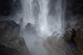
The Kings Dock is a small box canyon on the side of King George Gully on the rise to the south of the Fish River. The name is a silent play on speeches from the King's Dock protesting Irish patriotism, evoking O'Connell's speech at Tara, the seat of the Irish high kings. Near the top of the canyon are a couple of high eroded ramparts and 'seats' that are slowly collapsing into the gully.
 |
| The Kings Dock |
Box canyons played an important role in early settlement - serving as a convenient place to hold stock. A number of interesting erosion features can be seen from the top of the falls - higher than the surrounding land - perhaps they have been wind sculptured. Note that the Kings Dock is on private land, and permission would be required for a more detailed exploration. I am not sure of the provenance of the gate at the top of the fall - perhaps it is a boundary marker to prevent straying stock.
 |
| The Kings Dock from the top of the fall, note wind? erosion features at the top of the gully, in the distance. |
It is a silent place: a deep erosion gully that must change shape with each new discharge from the mountains above. Even in the dry, the edges of the canyon are capable of collapse. When the stream that falls into the canyon is flowing, the eroded granite ramparts of the canyon will make a pleasant backdrop to the unnamed falls here.


Comments